Current situation
Table 1 presents density indicators and objectives of postal establishments, in force up to 30.09.2017.
|
1. |
At national level, the concessionaire shall guarantee that the average number of inhabitants per postal establishment is lower than or equal to 4600 inhabitants. |
|
2. |
At national level, the concessionaire shall guarantee one postal establishment within the maximum distance of 6000 meters from the place of residence for 95% of the population. |
|
3. |
At the level of urban areas, which include predominantly and moderately urban areas, the concessionaire shall guarantee one postal establishment within the maximum distance of 4000 meters from the place of residence for 95% of the population. |
|
4. |
At the level of rural areas, which include predominantly rural areas, the concessionaire shall guarantee one postal establishment within the maximum distance of 11 000 meters from the place of residence for 95% of the population. |
|
5. |
In parishes with more than 20 000 inhabitants, the concessionaire shall guarantee at least one postal establishment providing the full range of concessionary services and an additional postal establishment providing the same range of services, for every additional 20 000 inhabitants. |
|
6. |
In parishes where the number of inhabitants exceeds 10 000 and is equal to or lower than 20 000 inhabitants, the concessionaire shall guarantee at least one postal establishment providing the full range of concessionary services. |
Source: ANACOM decision of 28.08.2014.
[Original] proposal submitted by CTT, on 09.03.2017:
CTT proposed the maintenance of the current set of density indicators of postal establishments and respective objectives.
CTT proposed also a methodological change in the measurement of indicators of maximum distance of accessibility to services. This change consists of the use of typologies of urban areas defined by INE in 20141 (TIPAU 2014), replacing typologies of urban areas currently used, which correspond to those defined by INE in 20092. This proposal is relevant for the purpose of the calculation of indicators 3 and 4 set out in Table 1.
Furthermore, CTT proposed a change in the methodology for calculation of indicators of maximum distance of accessibility to services (indicators 2 and 4). The calculation of these indicators was performed so far by ANACOM. It resulted from CTT’s proposal that the calculation of these Indicators would be undertaken “… by CTT and ANACOM, the database of Portugal’s road network acquired by each of these bodies being used to define the areas of influence of each postal establishment”.
ANACOM Decision of 05.06.2017:
ANACOM considered it appropriate:
a) To maintain the current set of density indicators of postal establishments and respective objectives;
b) To use the typologies of urban areas defined by INE in 2014, as they are more recent then those that are actually taken into account.
ANACOM did not accept the change, proposed by CTT, according to which the calculation of indicators 2, 3 and 4 would be performed both by CTT and by ANACOM. Not only did the Authority consider that CTT’s proposal was not substantiated, but it also considered that this change would lead to the achievement of different results, which could create market confusion and an absence of clear references for assessing compliance with these objectives. Therefore, without prejudice to the report by CTT of values achieved by those indicators (2, 3 and 4), this Authority considered that the relevant calculation for assessing compliance with the corresponding objectives should continue to be incumbent on ANACOM, using for the purpose an up-to-date road network database.
[Revised] proposal submitted by CTT, on 18.07.2017:
CTT clarifies that it had not intended calculations performed by both CTT and ANACOM to be used for the purpose of checking values achieved for indicators 2 and 4. It merely aimed to describe the way how each body calculated indicators, using road network databases, noting on this subject that the company is not aware whether ANACOM intends to maintain the road network database currently used and the respective updating period.
In this context, the wording now put forward by CTT remains the same as that currently in force, under ANACOM Decision of August 2014.
As regards the other issues, CTT maintains its original proposal, namely:
a) To maintain the current set of density indicators of postal establishments and respective objectives;
b) To use the typologies of urban areas defined by INE in 2014 (TIPAU 2014), to measure indicators of maximum distance of accessibility to services.
Position taken by ANACOM:
ANACOM restates that it agrees with the use of typologies of urban areas defined by INE in 2014 (TIPAU 2014), to measure indicators of maximum distance of accessibility to services, as they are more recent.
As regards the calculation of indicators 2, 3 and 4, it is deemed, as results from CTT’s current proposal, that ANACOM should continue to perform it, using for the purpose an up-to-date road network database.
As regards the road network database to be used by ANACOM, the wording presented by CTT on 09.03.2017 had the advantage of not making any reference to a specific commercial offer, which ANACOM finds to be beneficial, thus it is deemed that such wording should be adopted, duly adjusted, to the detriment of the wording now presented by CTT.
In this case, ANACOM will notify CTT of the road network database to be used and whenever any amendment is introduced thereto. Where the use of a different database results in significant changes in values achieved by indicators, this will be relevant to assess compliance with objectives or to revise such objectives, only to the extent that results from the adoption of a different database.
In this respect, ANACOM informs that it intends to use a different road network database, with proper up-to-date information, for the calculation of the referred indicators of maximum distance of accessibility to services.
Table 2 presents a comparison of values achieved by the end of 2016, with the current methodology (using the current road network database and current typologies of urban areas) and with the methodology that takes into account the road network database to be used in the future by ANACOM and the new TIPAU 2014 typologies of urban areas.
It may be seen that the global impact (incorporating both changes) is minor, ranging from -0.2 percentage points (p.p.) and +0.2 p.p., thus the change of values of objectives related to indicators under consideration seems not to be required.
| Objective | Value in the 4th quarter of 2016 (cfr. applicable calculation methodology) | Value in the 4th quarter of 2016 (using TIPAU 2014 and the new road network database) | Difference (p.p.) |
| At least one postal establishment within the maximum distance of 6000 meters from the place of residence for 95% of the population, at national level. | 96.80% | 96.80% | 0 p.p. |
| At least one postal establishment within the maximum distance of 4000 meters from the place of residence for 95% of the population, at the level of urban areas. | 95.90% | 95.90% | 0 p.p. |
| At least one postal establishment within the maximum distance of 11 000 meters from the place of residence for 95% of the population, at the level of rural areas. | 97.00% | 97.20% | + 0.2 p.p. |
| The maximum distance to a postal establishment providing the full range of concessionary services intended for the occasional segment is of 8500 meters for 97.5% of the population, at national level. (a) | 97.90% | 97.80% | - 0.1 p.p. |
| The maximum distance to a postal establishment providing the full range of concessionary services intended for the occasional segment is of 5500 meters for 97.5% of the population, at the level of urban areas. (a) | 98% | 97.80% | - 0.2 p.p. |
| The maximum distance to a postal establishment providing the full range of concessionary services intended for the occasional segment is of 15 000 meters for 97.5% of the population, at the level of rural areas. (a) | 98.40% | 98.30% | - 0.1 p.p. |
Source: ANACOM.
(a) Objectives of minimum services provided, analysed in Chapter 4.3.
As regards the proposal to maintain the current set of density indicators of postal establishments and respective objectives, ANACOM restates its agreement, set out in its decision of 05.06.2014, as well as the reasons that substantiate it, laid down in the same decision and which are fully reproduced below:
a) Maintenance of the objective “At national level, the concessionaire shall guarantee that the average number of inhabitants per postal establishment is lower than or equal to 4600 inhabitants.”
CTT’s proposal will allow the density of postal establishments, in the period between 2017 and 2020, to remain at the same level as today.
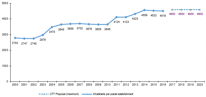
The value of the objective is constant over the period of time concerned, given that a constant population value is used, corresponding to values from the 2011 Census. By the end of 2016, the (achieved) value of the indicator was 4516 inhabitants per postal establishment, taking into account that 2339 postal establishments existed.
Figure 1 - Average number of inhabitants per postal establishment
Source: Information reported by CTT to ANACOM.
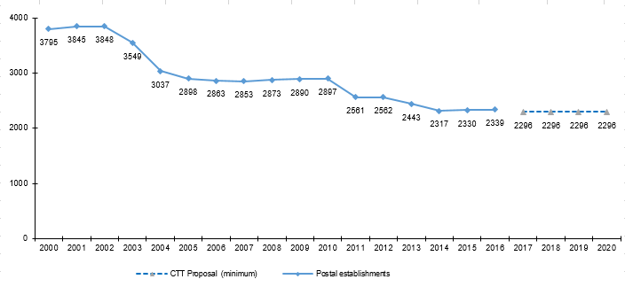
Compared to the situation by the end of 2016 and the objective established, in the period between 2017 and 2020, CTT is flexible to make some adjustments to the number of postal establishments. As such, between 2017 and 2020, the minimum possible number of postal establishments will be 2296, as is the case today.
Figure 2 - Evolution in the number of postal establishments (2000-2020) and minimum value underlying CTT’s proposal (2017-2020)
Source: Information reported by CTT to ANACOM.
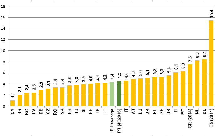
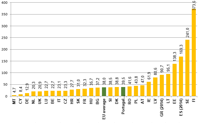
Bearing in mind data provided by the Universal Postal Union (UPU) on the network of fixed postal establishments of universal service providers in Member States of the European Union (EU), for 2015, Portugal compares slightly unfavourably to the EU average, in terms of the number of inhabitants and covered area (in km2) per postal establishment (vide figures 3 and 4).
Figure 3 - Density of fixed postal establishments in Member States of the European Union (EU), for 2015 (population, in thousands, per postal establishment)
Source: UPU, except BE (bpost reports & accounts for 2014) and FR (Registration Document 2015 - Annual financial report – La Poste). EU average without Portugal. PT (4Q2016), numbers in brackets refer to the year concerned. The population value taken into consideration refers to 2015.
Figure 4 - Coverage of fixed postal establishments in Member States of EU in 2015 (km2 per postal establishment)
Source: UPU, except BE (bpost reports & accounts for 2014) and FR (Registration Document 2015 - Annual financial report - La Poste). EU average without Portugal. PT (4Q2016), numbers in brackets refer to the year concerned. The population value taken into consideration refers to 2015.
According to the Survey on the Use of Postal Services - 20163 (2016 Survey), user satisfaction with the number of postal establishments reached an average of 8.3 in a scale from 1 to 10 (1 - not at all satisfied; 10 - very satisfied).
According to a study on the needs of users in accessing postal establishments and other points of access to the postal network, of May 2017, carried out by IMR for ANACOM4, most users (77.5% of residential users and 85.1% of business users) are satisfied with the characteristics of the current postal network and consider (84% of residential users and 81% of business users) that changes in the configuration of the density and characteristics of the current network are not required, rejecting a reduction in the number of post stations or post offices.
The same study also concludes that 77.5% of residential users and 91.4% of business users have used postal establishments and/or other points of access in the last 12 months (predominantly post stations and post offices), and around half of the business customers use at least once every week postal establishments and other points of access, and half of residential customers use them at least once every month, which represents an even more significant use of such facilities.
In the light of the above, this Authority considers that the objective proposed by CTT takes into account user needs.
b) Maintenance of indicators and objectives related to the distance of population to the nearest postal establishment
CTT proposes the maintenance of the three indicators related to the distance of resident population to the nearest postal establishment. Such indicators are as follows:
- At national level, the concessionaire shall guarantee one point of access within the maximum distance of 6000 meters from the place of residence for 95% of the population.
- At the level of urban areas, which include predominantly and moderately urban areas, the concessionaire shall guarantee one point of access within the maximum distance of 4000 meters from the place of residence for 95% of the population.
- At the level of rural areas, which include predominantly rural areas, the concessionaire shall guarantee one point of access within the maximum distance of 11 000 meters from the place of residence for 95% of the population.
As far as these indicators and respective objectives proposed are concerned, and taking also into account:
- Above-mentioned results of the recent study on the needs of users in accessing postal establishments and other points of access to the postal network;
- And that, according to that same study, any increase in the distance to postal establishments would lead to a negative reaction on the part of users5,
no reservations are raised by ANACOM. This will enable users in general to maintain, in the period between 2017 and 2020, the same level of accessibility to postal establishments and services that integrate the universal postal service.
Between 2014 and 2016, the value achieved by these indicators presented a positive evolution (vide Table 3).
|
2014 |
2015 |
2016 |
|
|
At national level, the concessionaire shall guarantee one point of access within the maximum distance of 6000 meters from the place of residence for 95% of the population |
96.7% |
96.8% |
96.8% |
|
At the level of urban areas, which include predominantly and moderately urban areas, the concessionaire shall guarantee one point of access within the maximum distance of 4000 meters from the place of residence for 95% of the population |
95.8% |
95.9% |
95.9% |
|
At the level of rural areas, which include predominantly rural areas, the concessionaire shall guarantee one point of access within the maximum distance of 11 000 meters from the place of residence for 95% of the population |
96.8% |
97.0% |
97.0% |
Source: ANACOM calculations.
According to the referred 2016 Survey, the degree of satisfaction of users (who use postal establishments) with the location of postal establishments reached an average of 8.4 in a scale from 1 to 10 (1 - not at all satisfied; 10 - very satisfied).
As referred earlier, according to the study carried out in 2017 by IMR for ANACOM, 77.5% of residential customers and 85.1% of business customers show a high level of satisfaction as regards points of access to the postal network.
c) Maintenance of indicators and objectives related to more heavily populated areas
CTT proposes to maintain that, in parishes:
- with more than 20 000 inhabitants, the concessionaire is required to ensure at least one postal establishment providing the full range of concessionary services and an additional postal establishment, providing the same range of services, for every additional 20 000 inhabitants;
- with residing population over 10 000 inhabitants and equal to or less than 20 000 inhabitants, the concessionaire is required to ensure the existence of at least one postal establishment providing a full range of concessionary services.
Bearing in mind that this proposal aims to maintain the level of coverage that currently exists in parishes with over 10 000 inhabitants, and in the light of results referred earlier of the study on needs of users in accessing postal establishments and other points of access to the postal network, the objectives proposed by CTT do not raise any reservations.
1 According to INE Determination No. 1494/2014, Official Gazette No. 144, II Series, of 29.07.2014, known as TIPAU 2014, bearing in mind the Official Administrative Map of Portugal resulting from the implementation of the Municipal Territorial Administrative Reorganisation (CAOP 2013).
2 The administrative reorganisation of the territory of parishes in 2013 being adjusted (2013 version of the Official Administrative Map of Portugal - CAOP), to consider for the whole territory of the new parish the typology assigned in 2009 to the former town hall.
3 Survey on the use of postal services 2016 - resident population. Methodological Note: The universe defined for the survey on the use of postal services is made up of individuals aged 15 years old or older, residing in conventional dwellings as their usual residence, located in Mainland Portugal or the Autonomous Regions (the Azores and Madeira). The sample included 1340 interviews stratified according to NUTII region. Data were collected via computer-assisted telephone interviews (CATI), on the basis of a questionnaire prepared by ANACOM. The fieldwork took place between 2 and 15 November 2016 and was undertaken by Nielsen. The observation unit was the person. Results were recalibrated so as to ensure the social and demographic structure of the Portuguese population aged 15 years old or older, according to results of INE’s 2011 Census. The maximum primary level margin of error results of a survey with a random sample of 1340 interviews is +/- 2.7 p.p. for a 95% confidence interval.
4 Study available at Needs of users in accessing postal establishments and other points of access to the postal networkhttps://www.anacom.pt/render.jsp?contentId=1413404. This study was presented at a workshop held on 14.07.2017, available at ''Workshop ''Estudos sobre as necessidades dos utilizadores dos serviços postaishttps://www.anacom.pt/render.jsp?contentId=1413480''.
5 According to this study, an increase by 5km to the current distance to reach the nearest postal establishment by car would lead 70.6% of residential customers and 57% of business customers to react negatively (and to adopt alternative solutions, such as digital solutions, or decrease the current level of correspondence).


